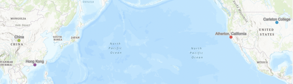
Our group decided to map the provenance and movement of a Chinese pot from the Neolithic period. The pot originated in China somewhere between 1600 and 700 BCE. In 1998, someone sold the pot in Hong Kong and it moved to Atherton, California before Carleton College acquired it in 2020. The mapping of the values was interesting but easy, considering it was from a CSV file. The file was finicky, though, because when we tried to access it, we realized that the file was invalid because of degree symbols and letters in the latitude and longitude section of our spreadsheet. Once we removed those, it was smooth sailing and the ArcGIS map came together very quickly.
ArcGIS is very useful to create these things since it allows for various imports of different files and maps them in a way that is pleasing to the eye. It only needs latitude and longitude because it will convert other fields automatically. The online platform is very user-friendly and definitely easy to work with. One cool feature is that you can toggle the scaling of the points on the map, so they can change size or stay the same size when a user zooms in. Content hosting on ArcGIS was very useful when we needed to import a CSV file from a link. I posted the file on my account and grabbed the link for it, and ArcGIS accepted it very smoothly.
ArcGIS could be very useful for mapping evolution and changes in location trends. This map consisted of multiple location points through time and could prove useful to map other artifacts’ journeys or even animals’ migration patterns. One other feature that proves very useful is the lightweight embedding in websites like this post. It reminds me of the glTF 3d model file format which is optimized for web browsing. There is so much potential for this kind of mapping and ArcGIS allows everyone to take part in the development of mapping and the viewing of all maps.
1 thought on “Mapping the Provenance of a Neolithic Pot”
Comments are closed.
That is so interesting that your file required specific latitude and longitude coordinates. In our version, it was able to find the locations just by their names in a column. How did you go about getting the coordinates? Did you just Google the locations so that it is easier to get into ArcGIS or use a different method? Overall, I do agree with you that ArcGIs is a really useful tool to map geographical trends and it would be interesting to explore what else can be done with the tool.